The Mi’kmaw, Maliseet, and Peskotomuhkati: Territory and Governance
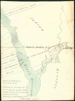
The territory that became New Brunswick in 1784 represented a significant portion of the territory controlled by the Maliseet (Wolastoqiyik), Mi’kmaq, and Peskotomuhkati (Passamaquoddy) nations. Each of these homelands was self-governed and the three nations were politically integrated.
Lying along the Wolastoq (St. John) River and its tributaries, Maliseet territory included central and western New Brunswick and extended into eastern Quebec and Maine. The Maliseet were governed locally by sakoms (chiefs). Sakoms were originally hereditary and assumed office for life, but from the late-nineteenth century many sakoms were elected for limited terms. The Wolastoqiyik were also part of a larger pan-Aboriginal organization, the Wabanaki Confederacy, which included Pannawampskéwiak (Penobscot), Wabaná’kiak (Abenaki), Mi’kmaw, and Peskotomuhkati representatives. Designed to coordinate unified political action and facilitate negotiations with British and other First Nations groups, the Wabanaki Confederacy was headquartered at Oldtown, Maine. Although it officially disbanded in 1862, the member groups remain allies.
The territory of the Peskotomuhkati straddles the St. Croix River and the Canada-United States border to include south-western New Brunswick and coastal Maine. Qonasqamkuk, an important Peskotomuhkati gathering place, sacred site, and political centre, is located at the site of modern St. Andrews. Since Confederation, the Peskotomuhkati of New Brunswick have struggled for recognition as Ottawa refuses to acknowledge Peskotomuhkati living on the Canadian side of the international border. Like that of the Maliseet, the territory of the Peskotomuhkati was governed locally by sakoms and was part of the broader political organization, the Wabanaki Confederacy.
The Mi’kmaw homeland, Mi’kma’ki, consists of seven districts: Kespek (eastern and northern New Brunswick, into Quebec), Siknikt (Cumberland County area, eastern New Brunswick and western Nova Scotia), Epexiwitk (Prince Edward Island), Kespukwitk (extreme southern Nova Scotia), Sipekne’katik (central Nova Scotia), Eskikewa’kik (north eastern mainland Nova Scotia), and Unama'kik (extreme northern mainland Nova Scotia and Cape Breton Island). In 1876 a complex political system governed Mi’kma’ki. Saqamaws, local chiefs, worked with the other chiefs representing the seven Mi’kmaw districts and the whole of Mi’kma’ki was politically integrated under the Sante’ Mawiomi, or Grand Council. The Sante’ Mawiomi, headquartered in Unama'kik on Cape Breton Island, was headed by the Kji-Saqmaw (Grand Chief). At meetings of the Sante’ Mawiomi, the Kji-Saqmaw and district chiefs (who brought forth the concerns of local Sakamows residing in their districts), addressed issues of war and diplomacy and attended to spiritual matters. The Mi’kmaq were, like their Maliseet and Peskotomuhkati neighbours, part of the Wabanaki Confederacy.
Martha Walls
Department of History, St. Francis Xavier University